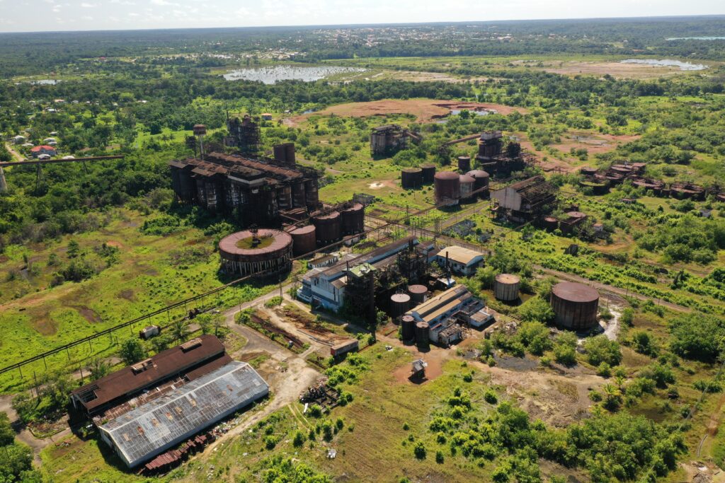
National Trust of Guyana

Region 10 (Upper Demerara-Berbice)

Alumina Plant

Location: Mackenzie, Linden  Classification: Industrial  Period/ Year Built: 1961  Historical Background / Description:  The Alumina Plant at the time of its construction was considered the largest and most expensive superstructure to be undertaken in British Guiana. It was built by the Demerara Bauxite Company (DEMBA) and is located at Spieghtland, (on Republic Avenue) Mackenzie, Linden.  …

Alumina Plant Read More »

Soesdyke /Linden Highway

Location: Ameila’s Ward, Linden  Classification: Civil Infrastructure  Period/ Year Built: 1968  Historical Background / Description:  The Soesdyke/Linden Highway is a two-lane road that stretches through Guyana’s hilly terrain. This road allows travellers to traverse from Soesdyke, Region four to Amelia’s Ward in Region 10, within the period of 2 hours. The highway was officially declared …

Soesdyke /Linden Highway Read More »

St. Aidan’s Anglican Church

Location: Wismar, Linden  Classification: Religious Period/ Year Built: Established 1897, rebuilt 1969  Historical Background / Description:  St. Aidan’s Anglican Church was established in 1897 in Malai, a settlement located up the Demerara River. In 1913, the church was moved across the river to Wismar to its current location on Burnham Drive.  The first church building …

St. Aidan’s Anglican Church Read More »

St. Matthew’s Church

Location: Christianburg, Linden  Classification: Religious  Period/ Year Built: 1898  Historical Background / Description:  St. Matthew’s Church is considered the oldest church in the town of Linden. It is located on Burnham Drive, Christianburg. The church was opened on November 25, 1898, and was built by the Presbyterians.  This single-storey, low-suspended colonial building faces the Demerara …

St. Matthew’s Church Read More »

Christianburg Waterwheel

Location: Christianburg, Linden  Classification: Engineering Structure  Period/ Year Built: Mid-19th century  Historical Background / Description:  Christianburg, located on the west bank of the Demerara River is Linden’s first settlement, and was known as Stabroek in the 19th century. Originally a Dutch settlement, the inhabitants were mostly involved in balata and rubber bleeding and later the …

Christianburg Waterwheel Read More »

Fort Nassau

Location: Fort Nassau, Upper Berbice  Classification: Historic Site (Archaeological)  Period/ Year Built: Established 1627  Historical Background / Description:  Fort Nassau was established in 1627 as a Dutch trading post. The remains of the fort is located approximately 88 kilometres (55 miles), from the mouth of the Berbice River (right bank) and borders Torani Creek. The …

Fort Nassau Read More »